![]()
![]()
![]()
![]()
You can create a spatial reference system (SRS) that uses an existing one as a template on which to base your settings using the Create Spatial Reference System Wizard.
Prerequisites
DBA authority or a member of the SYS_SPATIAL_ADMIN_ROLE group.
The unit of measure that you want to associate with the SRS must already exist.
Context and remarks
When you create a spatial reference system, you use an existing one as a template on which to base your settings. Therefore you should choose a spatial reference system that is similar to the one you want to create. Later, you can edit the settings.
 Create a spatial reference system (Sybase Central)
In Sybase Central, connect to the database as a user with DBA authority, or as a member of the SYS_SPATIAL_ADMIN_ROLE group.
In the left pane, right-click Spatial Reference Systems » New » Spatial Reference System.
Select Let Me Choose From The List Of All Predefined Spatial Reference Systems, and then click Next.
Follow the instructions in the wizard.
When you create a spatial reference system based on an existing spatial reference system, you set the SRID value to be 1000000000 plus the Well Known value.
When assigning a SRID, review the recommendations provided for ranges of numbers to avoid. These recommendations are found in the IDENTIFIED clause of the CREATE SPATIAL REFERENCE SYSTEM statement.
The definition for the spatial reference system appears.
If you are satisfied with the definition for the spatial reference system, click Finish.
Example
This example creates a spatial reference system based on an existing one.
Connect to the database as a user with DBA authority, or as a member of the SYS_SPATIAL_ADMIN_ROLE group.
In the left pane, right-click Spatial Reference Systems » New » Spatial Reference System.
Select Let Me Choose From The List Of All Predefined Spatial Reference Systems, and then click Next.
The Choose A Spatial Reference System window appears.
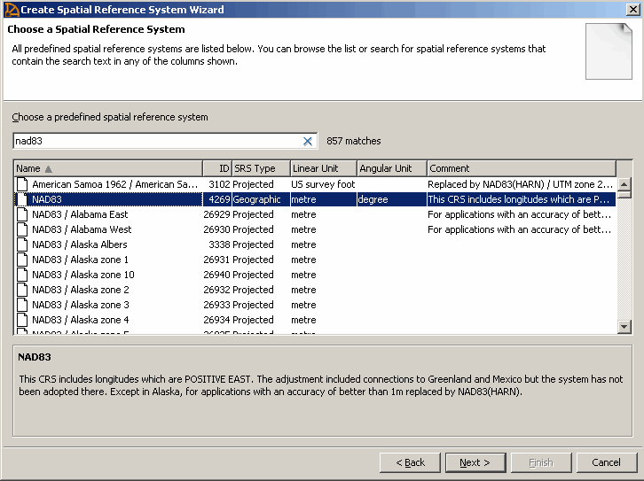
To create a spatial reference system based on the NAD83 spatial reference system, type NAD83. As you type a name or ID in the Choose A Predefined Spatial Reference System field, the list of spatial reference systems moves to display the spatial reference system you want to use as a template.
Click NAD83 and then click Next.
The Choose a Line Interpretation window appears.
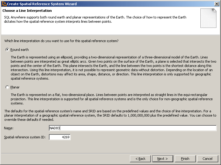
Click Round Earth to select it as the line interpretation.
Specify NAD83custom in the Name field.
When you create a spatial reference system based on an existing spatial reference system, you set the SRID value to be 1000000000 plus the Well Known value. For example, change the value in the Spatial Reference System ID field from 4269 to 1000004269.
When assigning a SRID, review the recommendations provided for ranges of numbers to avoid. These recommendations are found in the IDENTIFIED clause of the CREATE SPATIAL REFERENCE SYSTEM statement.
Click Next.
The Specify a Comment window appears.
Optionally, specify a description for the spatial reference system, and then click Next.
Click Finish.
The definition for the spatial reference system appears.
Click Finish.
See also |
Discuss this page in DocCommentXchange.
|
Copyright © 2012, iAnywhere Solutions, Inc. - SQL Anywhere 12.0.1 |