![]()
![]()
![]()
![]()
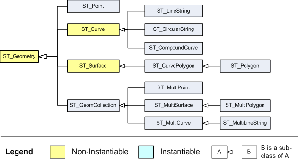
SQL Anywhere follows the SQL Multimedia (SQL/MM) standard for storing and accessing geospatial data. A key component of this standard is the use of the ST_Geometry hierarchy to define how geospatial data is created. Within the hierarchy, the prefix ST is used for all data types (also referred to as classes or just types).
When a column is identified as a specific type, the values of the type and its sub-classes can be stored in the column. For example, a column identified as ST_GeomCollection can also store the ST_MultiPoint, ST_MultiSurface, ST_MultiCurve, ST_MultiPolygon, and ST_MultiLineString values.
The following diagram illustrates the hierarchy of the ST_Geometry data type and its subtypes:
 Descriptions of supported spatial data types
 |
Discuss this page in DocCommentXchange.
|
Copyright © 2010, iAnywhere Solutions, Inc. - SQL Anywhere 12.0.0 |