SAP Sybase IQ supports both flat-Earth and round-Earth representations. Flat-Earth reference systems project all or a portion of the surface of the Earth to a flat, two dimensional plane (planar), and use a simple 2D Euclidean geometry. Lines between points are straight (except for circularstrings), and geometries cannot wrap over the edge (cross the dateline).
Round-Earth spatial reference systems use an ellipsoid to represent the Earth. Points are mapped to the ellipsoid for computations, all lines follow the shortest path and arc toward the pole, and geometries can cross the date line.
Both flat-Earth and round-Earth representations have their limitations. There is not a single ideal map projection that best represents all features of the Earth, and depending on the location of an object on the Earth, distortions may affect its area, shape, distance, or direction.
Limitations of round-Earth spatial reference systems
When working with a round-Earth spatial reference system such as WGS 84, many operations are not available. For example, computing distance is restricted to points or collections of points.
Some predicates and set operations are also not available.
Circularstrings are not allowed in round-Earth spatial reference systems.
Computations in round-Earth spatial reference systems are more expensive than the corresponding computation in a flat-Earth spatial reference system.
Limitations of flat-Earth spatial reference systems
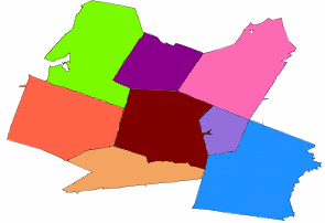
A flat-Earth spatial reference system is a planar spatial reference system that has a projection defined for it. Projection resolves distortion issues that occur when using a flat-Earth spatial reference system to operate on round-Earth data. For example of the distortion that occurs if projection is not used, the next two images show the same group of zip code regions in Massachusetts. The first image shows the data in a SRID 3586, which is a projected planar spatial reference system specifically for Massachusetts data. The second image shows the data in a planar spatial reference system without projection (SRID 1000004326). The distortion manifests itself in the second image as larger-than-actual distances, lengths, and areas that cause the image to appear horizontally stretched.


While more calculations are possible in flat-Earth spatial reference systems, calculations are only accurate for areas of bounded size, due to the effect of projection.
You can project round-Earth data to a flat-Earth spatial reference system to perform distance computations with reasonable accuracy provided you are working within distances of a few hundred kilometers. To project the data to a planar projected spatial reference system, you use the ST_Transform method.